updated 3:39pm
Monday: Increasing clouds. High 30. Light NE wind.
Monday Night: *Winter Storm Warning* Cloudy with snow developing after midnight. Low 22. Light NE wind. Chance of snow 70%. 1-2 inches of snow accumulation is expected.
Tuesday: *Winter Storm Warning* Cloudy with snow in the morning, mixing with freezing rain and sleet by late morning, then, periods of rain mixed with sleet ending by mid-afternoon. High 33. Wind NE 5 mph. Chance of precipitation 90%. 1-2 inches of snow and sleet accumulation in the morning.
Tuesday Night: *Winter Storm Warning* Cloudy with periods of freezing rain and sleet re-developing after midnight. Low 27. Wind NE 5 mph. Chance of precipitation 80%. Ice accumulation of a quarter to a half inch is expected, particularly on trees, power lines, cars, and untreated surfaces.
Wednesday: *Winter Storm Warning* Cloudy with sleet and freezing rain in the early morning, changing to rain and possibly heavy at times. The rain could end as a period of snow late in the afternoon. High 39. Wind NE 5 mph. Chance of precipitation 90%. A half inch to an inch of rain is expected.
Wednesday Night: Mostly cloudy. Low 25.
Thursday: Mostly sunny. High 31.
Thursday Night: Clear. Low 13.
Friday: Mostly cloudy. High 36.
Friday Night: Cloudy with a 40% chance of snow. Low 24.
Monday, January 31, 2011
Sunday, January 30, 2011
NJ Forecast - 1/30/11
Sunday: Mostly cloudy. High 36. Wind NW 5 mph.
Sunday Night: Partly cloudy. Low 16. Light N wind.
Monday: Increasing clouds. High 30. Light NE wind.
Monday Night: Cloudy with snow likely toward daybreak. Low 20. Light NE wind. Chance of snow 60%. Around an inch of snow expected.
Tuesday: Cloudy with snow in the morning, mixing with and changing to sleet and rain in the afternoon. High 34. Light E wind. Chance of precipitation 80%. An inch or two of snow and sleet accumulation is expected.
Tuesday Night: Cloudy with a 70% chance of rain, freezing rain, sleet and snow mixed. Low 28.
Wednesday: Cloudy and mild with a 90% chance of rain, mixing with sleet and snow late. High 46.
Wednesday Night: Clearing. Low 18.
Thursday: Sunny and much colder. High 26.
Thursday Night: Partly cloudy. Low 8.
Saturday, January 29, 2011
NJ Forecast - 1/29/11
Saturday: Cloudy with a 40% chance of light snow. High 34. Light W wind. A dusting of snow is possible.
Saturday Night: Cloudy with a 30% chance of a snow shower. Low 24. Wind calm.
Sunday: Cloudy. High 38. Wind NW 5 mph.
Sunday Night: Partly cloudy. Low 17. Light N wind.
Monday: Cloudy. High 29. Light NE wind.
Monday Night: Cloudy with a 40% chance of snow. Low 18.
Tuesday: Cloudy with a 50% chance of snow. High 29.
Tuesday Night: Cloudy with a 60% chance of snow. Low 22.
Wednesday: Cloudy with a 70% chance of snow, sleet or rain. High 35.
Wednesday Night: Mostly cloudy with a 40% chance of snow. Low 24.
Friday, January 28, 2011
NJ Forecast - 1/28/11
Friday: Cloudy with a 40% chance of light snow. High 36. Wind calm. Less than an inch of snow possible.
Friday Night: Cloudy with a 30% chance of a snow shower. Low 24. Wind calm.
Saturday: Cloudy with a 30% chance of a snow shower. High 34. Wind W 5 mph.
Saturday Night: Mostly cloudy. Low 21. Wind calm.
Sunday: Mostly cloudy. High 36. Light NW wind.
Sunday Night: Partly cloudy. Low 17.
Monday: Mostly cloudy. High 29.
Monday Night: Mostly cloudy. Low 15.
Tuesday: Mostly cloudy. High 29.
Tuesday Night: Cloudy with a 40% chance of snow. Low 15.
Thursday, January 27, 2011
January 26-27: What happened?

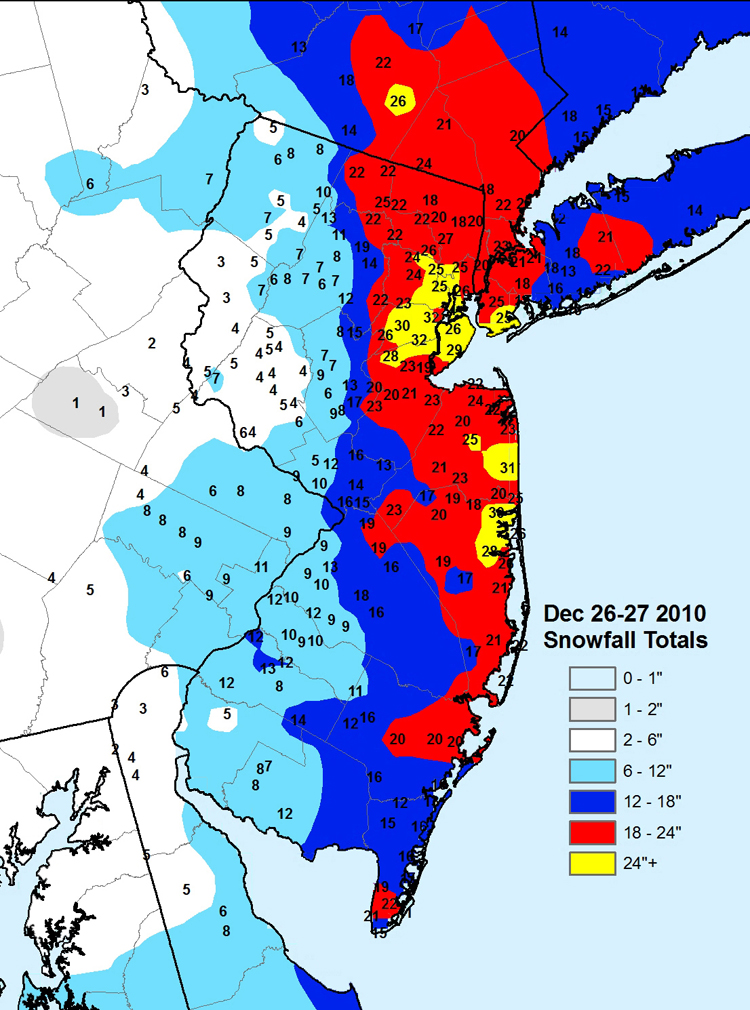
For those of you who regularly view this site for weather information (and I thank you), you might be wondering just what went wrong. Why did we get so much snow Wednesday morning when none was in the forecast? Why did we get so much more snow at night then was forecasted?
Snowstorms are notoriously tricky to forecast, and this one was more difficult than normal. To put it very simply, the weather forecasting models simply did not do a good job of handling this storm. Let's start with the morning snow, which caught so many by suprise. The forecast on this site, and all other forecasts I saw, either called for little or no precipitation at all for Wednesday morning. Computer models were surprisingly in good agreement leading into that period - basically the quantitative precipation models for the morning were dry! Precipitation was supposed to be light if any fell at all. And yet, most of the area received 3-5 inches of morning snow. It is hard to explain this failure except to say that an area of moisture can often precede the main center of the storm, and given the already cold air in place, a great deal of snow fell.
As far the later snow (the image above shows the total snowfall, courtesy of the Jeff Masters blog on the Weather Underground site www.wunderground.com), we clearly got much more snow than expected. As the storm deepened and colder air was brought in, the snow to liquid ratio quickly got larger, and strong bands of snow developed over our area, similar to December 26th's storm. As you can see, our area was literally the middle of the bullseye. Again, the models just did not see this coming. It is possible, as is mentioned in the above blog, that an overall climatic warming might actually lead to heavier snows, as slightly warmer area can handle more moisture. So we might be in for more extreme storms.
We still can only forecast based on the scientific data available, and none really got this one right. But I will keep at it and always try my best to provide you with up-to-date information.
NJ Forecast - 1/27/11
Thursday: Mostly cloudy. High 36. Wind NW 5-10 mph.
Thursday Night: Cloudy. Low 23. Wind calm.
Friday: Cloudy with a 40% chance of snow. High 35. Wind light and variable. Less than an inch of snow possible.
Friday Night: Cloudy. Low 24. Wind calm.
Saturday: Cloudy with a 40% chance of snow. High 36. Light SW wind. Less than an inch of snow possible.
Saturday Night: Partly cloudy. Low 21.
Sunday: Mostly sunny. High 37.
Sunday Night: Partly cloudy. Low 18.
Monday: Cloudy. High 34.
Monday Night: Cloudy with a 30% chance of snow. Low 22.
Wednesday, January 26, 2011
NJ Forecast - 1/26/11
update 1:18pm
update 3:51pm
Wednesday: *Winter Storm Warning* Cloudy with snow, heavy at times this morning. This afternoon, occasional light snow, sleet or rain is possible until around 3pm, then snow and sleet likely. High 36. Wind NE 5 mph. Chance of precipitation 100%. 2-5 inches of snow accumulation.
Wednesday Night: *Winter Storm Warning* Cloudy with sleet and snow changing back to all snow by 7pm, and becoming heavy at times, ending before daybreak. Low 27. Wind N 10 mph and gusty at times. Chance of precipitation 80%. A slight ice accumulation is possible, followed by 4-7 additional inches of snow.
Thursday: Mostly sunny. High 37. Wind NW 5-10 mph.
Thursday Night: Cloudy. Low 23. Wind calm.
Friday: Cloudy with a 30% chance of snow. High 38. Wind light and variable.
Friday Night: Mostly cloudy. Low 22.
Saturday: Cloudy with a 30% chance of snow. High 35.
Saturday Night: Partly cloudy. Low 21.
Sunday: Mostly sunny. High 33.
Sunday Night: Mostly cloudy. Low 16.
Tuesday, January 25, 2011
NJ Forecast - 1/25/11
updated 10:23am
updated 3:41pm
updated 9:19pm
Tuesday: Cloudy with light snow in the morning, and milder temperatures. High 37. Light W wind.
Tuesday Night: Mostly cloudy. Low 26. Light N wind.
Wednesday: *Winter Storm Watch* Cloudy with a mix of rain, sleet and wet snow, beginning in the afternoon. High 36. Wind NE 5 mph. Chance of precipitation 80%. Between a tenth and a quarter inch of rain expected. Little or no snow or ice accumulation.
Wednesday Night: *Winter Storm Watch* Cloudy with sleet and freezing rain changing to snow in the early evening, and becoming windy. Snow ending before daybreak. Low 26. Wind N 10-15 mph. Chance of precipitation 80%. A slight ice accumulation followed by 3-6 inches of snow is expected.
Thursday: Mostly sunny. High 36. Wind NW 5-10 mph.
Thursday Night: Partly cloudy. Low 19.
Friday: Cloudy with a 30% chance of snow. High 32.
Friday Night: Cloudy. Low 24.
Saturday: Mostly cloudy. High 37.
Saturday Night: Partly cloudy. Low 26.
Monday, January 24, 2011
NJ Forecast - 1/24/11
updated 12:12pm
Monday: Sunny and very cold. High 21. Wind calm.
Monday Night: Cloudy and not as cold, with temperatures rising overnight. Low 18.
Tuesday: Cloudy and milder. High 40. Light W wind.
Tuesday Night: Cloudy. Low 27. Wind calm.
Wednesday: Cloudy with a 60% chance of rain, possibly mixed with sleet or wet snow in the morning. High 40. Wind NE 5 mph. Between a tenth and a quarter of an inch of rain expected.
Wednesday Night: Cloudy with an 80% chance of rain in the evening, mixing with snow, sleet or freezing rain and then changing to snow. Low 28.
Thursday: Mostly sunny. High 37.
Thursday Night: Partly cloudy. Low 19.
Friday: Mostly sunny. High 35.
Friday Night: Mostly cloudy. Low 26.
Sunday, January 23, 2011
NJ Forecast - 1/23/11
Sunday: Mostly sunny and very cold. High 24. Wind NW 10 mph.
Sunday Night: Clear and extremely cold. Low 4. Light N wind.
Monday: Sunny and very cold. High 20. Wind light and variable.
Monday Night: Cloudy and very cold. Low 16. Wind calm.
Tuesday: Cloudy and milder with a 30% chance of a snow shower. High 39. Wind light and variable.
Tuesday Night: Mostly cloudy. Low 25.
Wednesday: Cloudy with a 50% chance of rain or snow. High 41.
Wednesday Night: Cloudy with a 50% chance of snow. Low 28.
Thursday: Mostly sunny. High 37.
Thursday Night: Partly cloudy. Low 17.
Saturday, January 22, 2011
NJ Forecast - 1/22/11
Saturday: Mostly cloudy and very cold. High 23. Wind NW 5 mph.
Saturday Night: Partly cloudy and very cold. Low 12. Light NW wind.
Sunday: Mostly sunny. High 27. Wind NW 5-10 mph.
Sunday Night: Partly cloudy and extremely cold. Low 5.
Monday: Mostly sunny and very cold. High 19.
Monday Night: Cloudy and very cold with a 40% chance of snow. Low 16.
Tuesday: Cloudy and milder with an 80% chance of snow. High 31.
Tuesday Night: Cloudy with a 50% chance of snow. Low 21.
Wednesday: Cloudy. High 35.
Wednesday Night: Partly cloudy. Low 21.
Friday, January 21, 2011
NJ Forecast - 1/21/11
Friday: Mostly sunny and breezy. High 34. Wind NW 10-15 mph.
Friday Night: Clear and very cold. Low 12. Wind NW 5-10 mph.
Saturday: Mostly sunny and very cold. High 23. Wind NW 5 mph.
Saturday Night: Cloudy and very cold. Low 11. Light NW wind.
Sunday: Mostly cloudy. High 26. Wind NW 5-10 mph.
Sunday Night: Clear and extremely cold. Low 4.
Monday: Mostly sunny and very cold. High 23.
Monday Night: Mostly cloudy and extremely cold. Low 7.
Tuesday: Cloudy. High 27.
Tuesday Night: Cloudy with a 40% chance of snow or sleet. Low 24.
Thursday, January 20, 2011
NJ Forecast - 1/20/11
updated 3:08pm
re-updated 10:40pm
Thursday: Cloudy and colder. High 33. Light NW wind.
Thursday Night: *Winter Weather Advisory* Cloudy with snow developing after 10PM. Low 26. Wind calm. Chance of snow 90%. 2-4 inches of snow accumulation expected.
Friday: Cloudy with a 20% chance of light snow early in the morning, then decreasing clouds and becoming breezy. High 33. Wind NW 10-15 mph.
Friday Night: Partly cloudy and very cold. Low 11. Wind NW 5-10 mph.
Saturday: Mostly cloudy and colder. High 22. Wind NW 5 mph.
Saturday Night: Mostly cloudy and very cold. Low 10.
Sunday: Mostly sunny and very cold. High 23.
Sunday Night: Partly cloudy and extremely cold. Low 4.
Monday: Cloudy and very cold with a 30% chance of snow. High 23.
Monday Night: Cloudy and very cold with a 30% chance of snow. Low 14.
Wednesday, January 19, 2011
NJ Forecast - 1/19/11
updated 3:39pm
Wednesday: Cloudy with a 30% chance of a shower. High 42. Light NW wind.
Wednesday Night: Mostly cloudy. Low 23. Light N wind.
Thursday: Cloudy and colder. High 32. Wind NW 5-10 mph.
Thursday Night: Cloudy with snow developing after midnight. Low 22. Wind light and variable. Chance of snow 90%. 1-3 inches of snow accumulation expected.
Friday: Cloudy with snow likely in the morning, then mostly cloudy in the afternoon. High 33. Wind NW 5-10 mph. Chance of snow 60%. Up to an additional inch of snow is expected.
Friday Night: Clear and very cold. Low 12.
Saturday: Mostly sunny and cold. High 22.
Saturday Night: Mostly cloudy and very cold. Low 9.
Sunday: Mostly sunny. High 26.
Sunday Night: Partly cloudy and very cold. Low 12.
Tuesday, January 18, 2011
NJ Forecast - 1/18/11
Tuesday: *Winter Storm Warning for Northern areas this morning* Cloudy with areas of freezing rain in the morning, but becoming milder with periods of rain through late morning and afternoon. High 41. Wind NE 5 mph. Chance of rain 100%. Around an inch of rain expected.
Tuesday Night: Cloudy with a 40% chance of rain. Low 31. Light NW wind. Around a tenth of an inch of rain possible.
Wednesday: Cloudy with a 40% chance of a shower. High 41. Wind NW 5 mph. Less than a tenth of an inch of rain possible.
Wednesday Night: Partly cloudy. Low 21. Wind N 5 mph.
Thursday: Cloudy and colder. High 31. Wind NW 5 mph.
Thursday Night: Cloudy with a 60% chance of snow. Low 21.
Friday: Cloudy with a 70% chance of snow. High 36.
Friday Night: Partly cloudy and very cold. Low 13.
Saturday: Mostly sunny. High 24.
Saturday Night: Partly cloudy. Low 9.
Monday, January 17, 2011
NJ Forecast - 1/17/11
Martin Luther King Jr. Day: Mostly cloudy. High 27. Light E wind.
Monday Night: *Winter Weather Advisory* Cloudy with snow developing after 11 p.m., accumulating 1-3 inches before changing to sleet and freezing rain around daybreak. A slight accumulation of ice is likely. Low 24. Wind NE 5 mph. Chance of precipitation 90%.
Tuesday: *Winter Weather Advisory* Cloudy with sleet and freezing rain early in the morning, changing to all rain by mid-morning. The rain could be heavy at times. Areas of fog possible. Milder, with a high around 38. Wind NE 5-10 mph. Chance of precipitation 90%. Between a half inch and an inch of rain expected.
Tuesday Night: Cloudy with a 30% chance of light snow, sleet or freezing rain. Low 30. Light NW wind.
Wednesday: Cloudy with a 40% chance of light rain or drizzle. High 43. Light NW wind. Less than a tenth of an inch of rain possible.
Wednesday Night: Partly cloudy. Low 24.
Thursday: Mostly cloudy. High 34.
Thursday Night: Cloudy with a 40% chance of snow. Low 24.
Friday: Mostly cloudy with a 30% chance of snow. High 39.
Friday Night: Partly cloudy. Low 16.
Sunday, January 16, 2011
NJ Forecast - 1/16/11
Sunday: Mostly sunny. High 33. Wind NW 5-10 mph.
Sunday Night: Mostly cloudy and very cold. Low 13. Light N wind.
Monday: Mostly sunny and very cold. High 25. Wind light and variable.
Monday Night: Cloudy with snow likely after midnight, possibly mixing with sleet or freezing rain toward daybreak. Low 21. Light NE wind. Chance of precipitation 60%. 1-3 inches of snow and sleet expected.
Tuesday: Cloudy with a a wintry mix early... changing to rain in the morning and becoming warmer. High 42. Wind SE 5 mph. Chance of precipation 90%. Between a half inch and an inch of rain expected.
Tuesday Night: Cloudy with a 70% chance of rain. Low 35.
Wednesday: Cloudy and mild. High 46.
Wednesday Night: Partly cloudy. Low 26.
Thursday: Mostly cloudy and cooler. High 36.
Thursday Night: Cloudy with a 40% chance of snow. Low 20.
Saturday, January 15, 2011
NJ Forecast - 1/15/11
Saturday: Cloudy with flurries possible. High 34. Light S wind.
Saturday Night: Cloudy with flurries possible. Low 26. Light W wind.
Sunday: Mostly sunny. High 32. Wind NW 5-10 mph.
Sunday Night: Partly cloudy and very cold. Low 12. Light N wind.
Monday: Mostly cloudy and very cold. High 25. Light N wind.
Monday Night: Cloudy with a 60% chance of snow, sleet or freezing rain. Low 21.
Tuesday: Cloudy and milder with a 90% chance of rain. High 41.
Tuesday Night: Cloudy with a 50% chance of rain. Low 33.
Wednesday: Cloudy with a 50% chance of rain. High 42.
Wednesday Night: Mostly cloudy. Low 23.
Friday, January 14, 2011
NJ Forecast - 1/14/11
Friday: Mostly cloudy. High 28. Wind NW 5 mph.
Friday Night: Mostly cloudy. Low 14. Wind calm.
Saturday: Cloudy. High 32. Light S wind.
Saturday Night: Cloudy with a 30% chance of light snow. Low 26. Light W wind.
Sunday: Mostly sunny. High 35. Wind NW 5-10 mph.
Sunday Night: Mostly cloudy. Low 14.
Monday: Cloudy. High 27.
Monday Night: Cloudy with a 50% chance of snow, sleet or freezing rain. Low 24.
Tuesday: Cloudy with a 60% chance of rain. High 43.
Tuesday Night: Mostly cloudy. Low 26.
Thursday, January 13, 2011
NJ Forecast - 1/13/11
Thursday: Mostly sunny. High 28. Wind NW 10-15 mph.
Thursday Night: Partly cloudy. Low 14. Light N wind.
Friday: Cloudy. High 29. Wind NW 5 mph.
Friday Night: Mostly cloudy. Low 18. Wind calm.
Saturday: Cloudy. High 33. Light SW wind.
Saturday Night: Cloudy with a 30% chance of snow. Low 25.
Sunday: Mostly sunny. High 36.
Sunday Night: Cloudy. Low 17.
Monday: Cloudy with a 30% chance of snow. High 31.
Monday Night: Cloudy with a 50% chance of snow. Low 28.
Wednesday, January 12, 2011
NJ Forecast - 1/12/11
Wednesday: Mostly cloudy. High 34. Wind NW 10 mph.
Wednesday Night: Cloudy. Low 20. Wind N 5-10 mph.
Thursday: Mostly sunny. High 29. Wind NW 10 mph.
Thursday Night: Partly cloudy. Low 14. Light N wind.
Friday: Mostly cloudy. High 29. Wind NW 5 mph.
Friday Night: Partly cloudy. Low 15.
Saturday: Cloudy. High 32.
Saturday Night: Cloudy. Low 26.
Sunday: Mostly cloudy. High 38.
Sunday Night: Partly cloudy. Low 21.
Tuesday, January 11, 2011
NJ Forecast - 1/11/11
updated 3:21pm
Tuesday: Cloudy. High 32. Light E wind.
Tuesday Night: *Winter Storm Warning* Cloudy with snow developing in the early evening, possibly heavy at times overnight. Low 26. Wind N 5 mph. Chance of snow 90%. 3-6 inches of snow expected with the highest amounts in the northern and eastern sections.
Wednesday: *Winter Storm Warning* Cloudy with snow likely, ending by mid-morning. High 34. Wind NW 5-10 mph. Chance of snow 60%. An additional inch of snow is expected.
Wednesday Night: Mostly cloudy. Low 19. Wind NW 10 mph.
Thursday: Mostly sunny and windy. High 29. Wind NW 10-15 mph.
Thursday Night: Partly cloudy. Low 14.
Friday: Mostly sunny. High 28.
Friday Night: Partly cloudy. Low 15.
Saturday: Cloudy. High 31.
Saturday Night: Cloudy with a 30% chance of snow. Low 25.
Monday, January 10, 2011
NJ Forecast - 1/10/11
updated 3:25pm
Monday: Sunny. High 32. Wind NW 5-10 mph.
Monday Night: Partly cloudy. Low 17. Light NW wind.
Tuesday: Cloudy. High 32. Wind light and variable.
Tuesday Night: *Winter Storm Warning* Cloudy with snow. Low 26. Wind N 5-10 mph. Chance of snow 80%. 4-8 inches of snow expected, with highest amounts in the northern and eastern sections.
Wednesday: *Winter Storm Warning* Cloudy with snow likely in the morning. High 35. Wind NW 10 mph. Chance of snow 70%. An additional inch or two of snow is expected.
Wednesday Night: Cloudy. Low 21.
Thursday: Mostly cloudy. High 32.
Thursday Night: Mostly cloudy. Low 19.
Friday: Mostly cloudy. High 30.
Friday Night: Partly cloudy. Low 17.
Sunday, January 9, 2011
NJ Forecast - 1/9/11
Sunday: Mostly sunny and windy. High 33. Wind NW 10-15 mph.
Sunday Night: Clear. Low 18. Wind N 5-10 mph.
Monday: Sunny. High 34. Wind NW 5-10 mph.
Monday Night: Clear. Low 19. Light NW wind.
Tuesday: Cloudy with a 30% chance of afternoon snow. High 33. Wind light and variable.
Tuesday Night: Cloudy with an 80% chance of snow. Low 28.
Wednesday: Mostly cloudy with a 40% chance of snow. High 39.
Wednesday Night: Mostly cloudy. Low 23.
Thursday: Mostly cloudy. High 34.
Thursday Night: Mostly cloudy. Low 20.
Saturday, January 8, 2011
NJ Forecast - 1/8/11
Saturday: Cloudy with light snow likely. High 32. Light N winds. Chance of snow 70%. Around an inch of snow expected, possibly higher in the south.
Saturday Night: Cloudy with a 30% chance of evening snow. Low 21. Wind NW 5-10 mph. Little additional accumulation possible.
Sunday: Mostly cloudy and breezy. High 34. Wind NW 10-15 mph.
Sunday Night: Clear. Low 18. Wind N 5-10 mph.
Monday: Mostly sunny. High 32. Wind NW 5-10 mph.
Monday Night: Mostly cloudy. Low 20.
Tuesday: Cloudy with a 50% chance of snow. High 36.
Tuesday Night: Cloudy with a 50% chance of snow. Low 28.
Wednesday: Cloudy with a 30% chance of snow. High 37.
Wednesday Night: Mostly cloudy. Low 23.
Friday, January 7, 2011
NJ Forecast - 1/7/11
updated 6:15 pm
Friday: Cloudy with snow, mostly in the morning. High 36. Wind SW 5 mph. Chance of snow 80%. 1-2 inches of snow expected, with some localized areas of up to 3 inches, mostly north.
Friday Night: Mostly cloudy. Low 20. Wind calm.
Saturday: Cloudy with a 40% chance of snow showers. High 31. Light NW wind. Up to 2 inches of snow possible.
Saturday Night: Mostly cloudy. Low 19. Wind NW 5-10 mph.
Sunday: Mostly sunny and breezy. High 34. Wind NW 10-15 mph.
Sunday Night: Clear. Low 20.
Monday: Sunny. High 35.
Monday Night: Mostly cloudy. Low 22.
Tuesday: Cloudy with a 30% chance of snow. High 35.
Tuesday Night: Cloudy with a 30% chance of snow. Low 26.
Thursday, January 6, 2011
Storm Tracking - Why Forecasting Snowfall is so Tough
By now, even the areas that were hardest hit by the snowstorm which struck our area on December 26th and 27th have been able to dig out. We have all had time to reflect on that storm, and the most common question I've heard from those who read my forecast is, "Why was this storm such a surprise?"
Since most of the forecasts I saw in the days leading up to the storm did, in fact, call for snow, it seems that what people are questioning is what appears to be the unforeseen intensity of the storm. The WeatherNJ forecast first mentioned the storm on December 23rd, 3 days before the storm hit our area. Each subsequent forecast reiterated the possibility of measurable snowfall for the 26th. However, those forecasts all called for light snow. Even on the 25th, the forecast did not suggest the extreme snow totals some in our areas received. What caused this inaccuracy?
In some respects, the forecasted snow amounts given on the 25th were not in error, depending on where you live. This map, from the Office of the State Climatologist http://climate.rutgers.edu/stateclim/images/Dec26_27_2010_NJ_snow.jpg, shows the extremely tight gradient we experienced in this storm.

In the WeatherNJ forecast area (central NJ), an accurate forecast would have been one which called for an outrageous 5-30 inches of snow! This type of forecast is similar to calling your cable company for repairs, and having them tell you they will be at your house anywhere from 15 minutes to 3 days from now! The WeatherNJ forecast of 6-11 inches of snow was accurate for the western third of the forecast area, but the snowfall bulls-eye seen in our NJ's easternmost counties is very rare, and hard to predict.
This shows the extreme importance that storm track has on the snowfall forecasts for New Jersey, especially when looking at the east coast's infamous nor'easters. A storm track just 30 miles further east would have spared nearly all of NJ the highest amounts of snowfall experienced. And the storm track is often the most difficult part of forecasting any weather event.
NJ Forecast - 1/6/11
Thursday: Cloudy. High 36. Wind light and variable.
Thursday Night: Cloudy with a 30% chance of light snow toward daybreak. Low 26. Wind calm.
Friday: Cloudy with periods of light snow. High 35. Wind light and variable. Chance of snow 80%. 1-3 inches of snow expected, with the highest amounts to the north.
Friday Night: Cloudy. Low 21. Wind NW 5-10 mph.
Saturday: Cloudy. High 32. Wind W 5 mph.
Saturday Night: Partly cloudy. Low 19.
Sunday: Mostly sunny. High 34.
Sunday Night: Clear. Low 21.
Monday: Mostly sunny. High 37.
Monday Night: Cloudy with a 30% chance of snow. Low 24.
Wednesday, January 5, 2011
NJ Forecast - 1/5/11
updated 4:05pm
Wednesday: Mostly sunny. High 39. Wind NW 5-10 mph.
Wednesday Night: Increasing clouds. Low 24. Wind calm.
Thursday: Cloudy. High 37. Light SW wind.
Thursday Night: Cloudy with light snow possible just before daybreak. Low 27. Wind light and variable. Chance of snow 30%.
Friday: Cloudy with light snow likely. High 36. Wind light and variable. Chance of snow 70%. 1-2 inches of snow is likely.
Friday Night: Cloudy with a 50% chance of snow. Low 24.
Saturday: Cloudy with a 40% chance of snow. High 35.
Saturday Night: Mostly cloudy. Low 21.
Sunday: Mostly sunny. High 35.
Sunday Night: Partly cloudy. Low 19.
Tuesday, January 4, 2011
NJ Forecast - 1/4/11
Tuesday: Mostly cloudy. High 42. Wind SW 5 mph.
Tuesday Night: Partly cloudy. Low 27. Light NW wind.
Wednesday: Mostly sunny. High 40. Wind NW 5-10 mph.
Wednesday Night: Cloudy. Low 25. Wind calm.
Thursday: Cloudy. High 38. Wind light and variable.
Thursday Night: Cloudy with a 50% chance of snow. Low 27.
Friday: Cloudy with a 50% chance of snow. High 38.
Friday Night: Cloudy. Low 20.
Saturday: Mostly sunny. High 35.
Saturday Night: Partly cloudy. Low 24.
Monday, January 3, 2011
NJ Forecast - 1/3/11
Monday: Mostly sunny and cooler. High 37. Wind NW 5-10 mph.
Monday Night: Mostly cloudy. Low 24. Wind calm.
Tuesday: Mostly cloudy. High 41. Wind SW 5 mph.
Tuesday Night: Partly cloudy. Low 27. Light NW wind.
Wednesday: Mostly sunny. High 39. Wind NW 5 mph.
Wednesday Night: Partly cloudy. Low 23.
Thursday: Cloudy. High 39.
Thursday Night: Cloudy with a 30% chance of snow. Low 26.
Friday: Mostly sunny. High 35.
Friday Night: Partly cloudy. Low 18.
Sunday, January 2, 2011
NJ Forecast - 1/2/11
Sunday: Cloudy with a 40% chance of a shower. High 49. Light NW wind. Less than a tenth of an inch of rain possible.
Sunday Night: Clear. Low 25. Wind N 5 mph.
Monday: Mostly sunny and colder. High 37. Wind NW 5-10 mph.
Monday Night: Mostly cloudy. Low 24. Wind calm.
Tuesday: Mostly cloudy. High 41. Wind light and variable.
Tuesday Night: Partly cloudy. Low 26.
Wednesday: Mostly sunny. High 38.
Wednesday Night: Cloudy. Low 24.
Thursday: Cloudy with a 50% chance of rain. High 35.
Thursday Night: Cloudy with a 30% chance of snow. Low 27.
Saturday, January 1, 2011
NJ Forecast - 1/1/11
New Year's Day: Cloudy. High 49. Light S wind.
Saturday Night: Cloudy and mild with showers likely. Low 38. Wind calm. Chance of rain 70%. Around a tenth of an inch of rain expected.
Sunday: Mostly cloudy. High 48. Light NW wind.
Sunday Night: Clear. Low 25. Wind NW 5 mph.

Monday: Sunny and colder. High 38. Wind NW 5-10 mph.
Monday Night: Clear. Low 24.
Tuesday: Mostly sunny. High 43.
Tuesday Night: Partly cloudy. Low 27.
Wednesday: Mostly sunny. High 39.
Wednesday Night: Partly cloudy. Low 21.
Saturday Night: Cloudy and mild with showers likely. Low 38. Wind calm. Chance of rain 70%. Around a tenth of an inch of rain expected.
Sunday: Mostly cloudy. High 48. Light NW wind.
Sunday Night: Clear. Low 25. Wind NW 5 mph.
Monday: Sunny and colder. High 38. Wind NW 5-10 mph.
Monday Night: Clear. Low 24.
Tuesday: Mostly sunny. High 43.
Tuesday Night: Partly cloudy. Low 27.
Wednesday: Mostly sunny. High 39.
Wednesday Night: Partly cloudy. Low 21.
Subscribe to:
Posts (Atom)