
Showing posts with label discussion. Show all posts
Showing posts with label discussion. Show all posts
Friday, August 7, 2015
Dry weather in NJ


Friday, July 5, 2013
June 2013 Precipitation
The month of June was certainly a wet one in central NJ. In total, most of central NJ received between 9 and 11 inches of rain for the month, with 10.16 inches officially recorded in Trenton, NJ. The statewide average, according to the Office of the New Jersey State Climatologist, was 9.57 inches, and was a record for the month of June, dating back over 100 years. Areas of central NJ and southwestern NJ were the wettest, while areas along the shore, while still quite wet, were drier, with some areas receiving only 6-8 inches of rain. The normal rain total is 4.41 inches.
Central NJ received rain 17 out of 30 days in June. For most of the state, June's precipitation was over 200% of the normal for the month. All of this extra rain has resulted in the area being about 25-50% above normal for the last three months, and about 10-25% above normal for the past 6 months. This is good for avoiding drought as we head into what is typically a drier period for NJ overall during the summer months. The current forecast from the Climate Prediction Center for the July-August-September period is for roughly normal precipitation for NJ.
Central NJ received rain 17 out of 30 days in June. For most of the state, June's precipitation was over 200% of the normal for the month. All of this extra rain has resulted in the area being about 25-50% above normal for the last three months, and about 10-25% above normal for the past 6 months. This is good for avoiding drought as we head into what is typically a drier period for NJ overall during the summer months. The current forecast from the Climate Prediction Center for the July-August-September period is for roughly normal precipitation for NJ.
Wednesday, April 18, 2012
No forecast, but rain news
No forecast today due to schedule conflicts, but the good news is rain is on the way. It appears that this weekend we could see perhaps an inch of rain. More tomorrow in my forecast.
Saturday, August 27, 2011
5PM update
No change in projected storm track. Irene has weakened - maximum sustained winds are now 80 mph. This is evidenced on radar and enhanced satellite images as well. That does not mean, however, that central NJ will not receive 4-8 inches of rain, and tropical storm force winds. Those conditions are still expected, mostly between 10PM tonight and 10AM tomorrow morning. Already some moderate to heavy rain has worked into our area.
The good news is that some of the winds over inland NC and VA have been only in the 20-40 mph range. The bad news is that those areas have received 6-10 inches of rain, and most of that, albeit perhaps slightly weakened, is headed our way. Unfortunately, I have seen reports of 500,000 people in VA without power. Hopefully, we will fare better in that respect. If the storm continues to weaken, perhaps that will be the case.
The good news is that some of the winds over inland NC and VA have been only in the 20-40 mph range. The bad news is that those areas have received 6-10 inches of rain, and most of that, albeit perhaps slightly weakened, is headed our way. Unfortunately, I have seen reports of 500,000 people in VA without power. Hopefully, we will fare better in that respect. If the storm continues to weaken, perhaps that will be the case.
11AM update
Unfortunately, the 11AM update pushed the track of the eye of Irene westward a bit, suggesting a secondary landfall to take place in NJ, just north of Atlantic City. This, of course, would be very bad news for Long Beach Island which could now be on the east side of the eye wall. The hurricane at that time would be a very weak category 1 storm, but still, it would be better for the NJ coast if the storm's eye stayed offshore.
This new track, if correct, would not have too much impact on our forecast area. Perhaps slightly higher winds, for a slightly longer period. I still think that wind intensity will decrease fairly quickly the further one is away from the shoreline. But a 12 hour period of occasionally heavy rain, and 20-40 mph sustained winds (with higher gusts) look likely.
This new track, if correct, would not have too much impact on our forecast area. Perhaps slightly higher winds, for a slightly longer period. I still think that wind intensity will decrease fairly quickly the further one is away from the shoreline. But a 12 hour period of occasionally heavy rain, and 20-40 mph sustained winds (with higher gusts) look likely.
Friday, August 26, 2011
Irene 11PM update
New models show no change in storm track. Irene appears likely to skirt NJ coastline. There is a good chance that it will do so as either a very weak category 1 hurricane, or very strong tropical storm. Either way, 4-8 inches of rain, and winds from 20-40 mph, with higher gusts, still seem probable.
More information tomorrow morning.
More information tomorrow morning.
Irene 6:30PM 8/26 update
No big changes from the 5PM model update, or from the other computer models. At the moment, the storm's eye still looks likely to hug the coastline. Tropical storm-force winds extend far enough from the center of circulation, that during the peak hours of the storm (2AM - 10AM Sunday) nearly all of NJ could see sustained winds over 30 mph. 4-8 inches of rain still looks about right for most areas.
By 3PM Sunday, the storm and all the rain and wind should be out of the area. Monday through Wednesday look to be nice days. Hopefully, we will all be able to enjoy them with no problems.
By 3PM Sunday, the storm and all the rain and wind should be out of the area. Monday through Wednesday look to be nice days. Hopefully, we will all be able to enjoy them with no problems.
Irene discussion - 3PM 8/26
The forecast models have continued to wobble back and forth regarding the eventual track of the eye of Hurricane Irene. For several days, the storm track moved consistently east. Then late Wednesday night, the storm track began shifting west, until it was almost directly over our area. Then late last night, it started shifting slightly east again. The current track is off the NJ coast, but very close to the actual coastline.
Of course, this is just the eye of the storm. The storm is wide enough that all of NJ, and eastern PA, will be affected in some way. At this point, there is very little chance of the storm missing the area entirely. It is great news that the eye of the storm should pass offshore, thus allowing nearly all of NJ to bypass the hurricane-force winds, and heaviest rainfall. However, a good portion of NJ should still see tropical storm-force winds and moderate to heavy rain.
As for timing and intensity... it now looks like most of the forecast area should begin to see rain starting in the late afternoon Saturday. The rain should be showery until around 10PM when it should become steadier. The heaviest rain should take place between 2AM and 10AM Sunday. In general, most areas will likely receive 4-8 inches of rain, with some areas far west receiving maybe as little as 3", and areas further east perhaps getting as much as 10".
With regard to winds, the wind intensity should not pick up until around 11PM Saturday. The strongest winds should be between 2AM and 10AM Sunday. Most areas will likely see winds in the 15-30 mph range, but there will be gusts up to 50 mph, especially early Sunday morning.
This forecast can still change somewhat, depending on the track of the storm. However, as previously stated, the chance of a "miss" is very slim. I will issue further updates this evening, later tonight, and tomorrow.
Of course, this is just the eye of the storm. The storm is wide enough that all of NJ, and eastern PA, will be affected in some way. At this point, there is very little chance of the storm missing the area entirely. It is great news that the eye of the storm should pass offshore, thus allowing nearly all of NJ to bypass the hurricane-force winds, and heaviest rainfall. However, a good portion of NJ should still see tropical storm-force winds and moderate to heavy rain.
As for timing and intensity... it now looks like most of the forecast area should begin to see rain starting in the late afternoon Saturday. The rain should be showery until around 10PM when it should become steadier. The heaviest rain should take place between 2AM and 10AM Sunday. In general, most areas will likely receive 4-8 inches of rain, with some areas far west receiving maybe as little as 3", and areas further east perhaps getting as much as 10".
With regard to winds, the wind intensity should not pick up until around 11PM Saturday. The strongest winds should be between 2AM and 10AM Sunday. Most areas will likely see winds in the 15-30 mph range, but there will be gusts up to 50 mph, especially early Sunday morning.
This forecast can still change somewhat, depending on the track of the storm. However, as previously stated, the chance of a "miss" is very slim. I will issue further updates this evening, later tonight, and tomorrow.
Thursday, August 25, 2011
Thoughts on Irene - 9PM Thursday 25th
The most recent anticipated storm track of Irene suggests that the center of the hurricane will hug the NJ coast, passing by central NJ around 2PM on Sunday. This track has been relatively stable over the past 12 hours. There have been some wobbles westward, and the most recent update has a slight eastward wobble. But overall, the track's stability leads me to believe that there will not likely be major changes to come.
If this is the case, central NJ would likely be in for rain beginning late Saturday afternoon, becoming heavy before midnight. The heaviest rain would take place after midnight Sunday, until the storm passes our area Sunday afternoon. Winds would likely pick up overnight Sunday (during the wee hours of the morning), with the worst of the winds (probably mostly in the 30-50 mph range) blowing through the area Sunday from 9AM to 3PM. The 6AM to 3PM window is the most likely time for wind-related damage to occur, and this would also be the period where flash-flooding, if it happens, would occur as well. Also, if any tornadoes were spawned by the storm, they would probably take place during this time.
Of course, if the storm tracks further east, and this is still quite possible, then most of the impact I just described would be minimized for our area. But unless and until the forecast track moves away from this area, I would encourage all central NJ residents, but especially those prone to flooding and wind-related problems, to take sensible and reasonable precautions. Irene should not cause anyone to panic, but this storm, which could be unlike any that most NJ residents have experienced, should not be ignored.
If this is the case, central NJ would likely be in for rain beginning late Saturday afternoon, becoming heavy before midnight. The heaviest rain would take place after midnight Sunday, until the storm passes our area Sunday afternoon. Winds would likely pick up overnight Sunday (during the wee hours of the morning), with the worst of the winds (probably mostly in the 30-50 mph range) blowing through the area Sunday from 9AM to 3PM. The 6AM to 3PM window is the most likely time for wind-related damage to occur, and this would also be the period where flash-flooding, if it happens, would occur as well. Also, if any tornadoes were spawned by the storm, they would probably take place during this time.
Of course, if the storm tracks further east, and this is still quite possible, then most of the impact I just described would be minimized for our area. But unless and until the forecast track moves away from this area, I would encourage all central NJ residents, but especially those prone to flooding and wind-related problems, to take sensible and reasonable precautions. Irene should not cause anyone to panic, but this storm, which could be unlike any that most NJ residents have experienced, should not be ignored.
Thursday, January 6, 2011
Storm Tracking - Why Forecasting Snowfall is so Tough
By now, even the areas that were hardest hit by the snowstorm which struck our area on December 26th and 27th have been able to dig out. We have all had time to reflect on that storm, and the most common question I've heard from those who read my forecast is, "Why was this storm such a surprise?"
Since most of the forecasts I saw in the days leading up to the storm did, in fact, call for snow, it seems that what people are questioning is what appears to be the unforeseen intensity of the storm. The WeatherNJ forecast first mentioned the storm on December 23rd, 3 days before the storm hit our area. Each subsequent forecast reiterated the possibility of measurable snowfall for the 26th. However, those forecasts all called for light snow. Even on the 25th, the forecast did not suggest the extreme snow totals some in our areas received. What caused this inaccuracy?
In some respects, the forecasted snow amounts given on the 25th were not in error, depending on where you live. This map, from the Office of the State Climatologist http://climate.rutgers.edu/stateclim/images/Dec26_27_2010_NJ_snow.jpg, shows the extremely tight gradient we experienced in this storm.
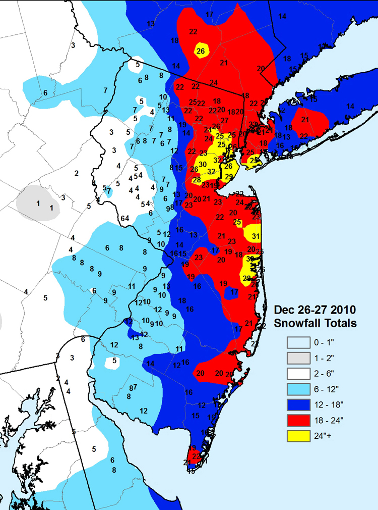

In the WeatherNJ forecast area (central NJ), an accurate forecast would have been one which called for an outrageous 5-30 inches of snow! This type of forecast is similar to calling your cable company for repairs, and having them tell you they will be at your house anywhere from 15 minutes to 3 days from now! The WeatherNJ forecast of 6-11 inches of snow was accurate for the western third of the forecast area, but the snowfall bulls-eye seen in our NJ's easternmost counties is very rare, and hard to predict.
This shows the extreme importance that storm track has on the snowfall forecasts for New Jersey, especially when looking at the east coast's infamous nor'easters. A storm track just 30 miles further east would have spared nearly all of NJ the highest amounts of snowfall experienced. And the storm track is often the most difficult part of forecasting any weather event.
Subscribe to:
Posts (Atom)