By now, even the areas that were hardest hit by the snowstorm which struck our area on December 26th and 27th have been able to dig out. We have all had time to reflect on that storm, and the most common question I've heard from those who read my forecast is, "Why was this storm such a surprise?"
Since most of the forecasts I saw in the days leading up to the storm did, in fact, call for snow, it seems that what people are questioning is what appears to be the unforeseen intensity of the storm. The WeatherNJ forecast first mentioned the storm on December 23rd, 3 days before the storm hit our area. Each subsequent forecast reiterated the possibility of measurable snowfall for the 26th. However, those forecasts all called for light snow. Even on the 25th, the forecast did not suggest the extreme snow totals some in our areas received. What caused this inaccuracy?
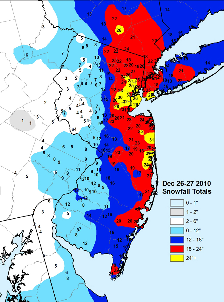
In some respects, the forecasted snow amounts given on the 25th were not in error, depending on where you live. This map, from the Office of the State Climatologist http://climate.rutgers.edu/stateclim/images/Dec26_27_2010_NJ_snow.jpg, shows the extremely tight gradient we experienced in this storm.

In the WeatherNJ forecast area (central NJ), an accurate forecast would have been one which called for an outrageous 5-30 inches of snow! This type of forecast is similar to calling your cable company for repairs, and having them tell you they will be at your house anywhere from 15 minutes to 3 days from now! The WeatherNJ forecast of 6-11 inches of snow was accurate for the western third of the forecast area, but the snowfall bulls-eye seen in our NJ's easternmost counties is very rare, and hard to predict.
This shows the extreme importance that storm track has on the snowfall forecasts for New Jersey, especially when looking at the east coast's infamous nor'easters. A storm track just 30 miles further east would have spared nearly all of NJ the highest amounts of snowfall experienced. And the storm track is often the most difficult part of forecasting any weather event.
No comments:
Post a Comment